The Greatest Grid:
The Master Plan of Manhattan, 1811–2011
Museum of the City of New York
1220 Fifth Avenue
Through April 6, 2012
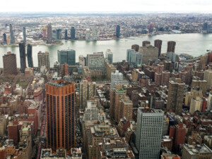
In 1807, to head off health threats and a growing lack of habitable space, New York City’s Common Council commissioned a three-year project to organize massive land development north of Houston Street. The Museum of the City of New York presents The Greatest Grid: The Master Plan of Manhattan, 1811–2011 in honor of the bicentennial of the 1811 Commissioners’ Plan for New York, which established the iconic street grid from Houston to 155th Street. Along with the original, hand-drawn map of New York’s grid plan, other historic documents demonstrate the city’s physical development due to the grid’s application and evolution over time. Co-presented by the Museum of the City of New York, the New York Public Library, and The Architectural League of New York, and sponsored by the Office of the Manhattan Borough President, The Greatest Grid will be on display until April 6.
Click on a thumbnail to launch the slideshow.


