
National attention focused on the recent opening of the Expo Line, an 8.6-mile light rail route that connects downtown LA with Culver City. But that’s just the tip of the iceberg. Before all is said and done, Los Angeles —long stereotyped as a car-only city—will have more than 100 miles of public transit lines, as the West Coast, home to the nation’s first light rail line in San Diego and to its most comprehensive light rail system in Portland, continues to add a slew of new rail.
New lines, stations, infrastructure, and transit-oriented developments are popping up and in planning stages in and around Seattle, Portland, San Francisco, Sacramento, Los Angeles and San Diego. And if you count West Coast–adjacent cities such as Phoenix and Denver, there are even more. Los Angeles and Seattle are set to double their offerings while Marin and Sonoma are just beginning to add rail to the mix.
Of course, this transit explosion isn’t just a local trend. According to the American Public Transportation Association, from 1995 through 2010, public transportation ridership increased by 31 percent—a growth rate higher than the 17 percent increase in the U.S. population. In part this shift is a result of people returning to urban cores. But perhaps the most compelling reason for the expansion is the crippling impact of traffic in the region and in the country, and its accompanying demons—sprawl, pollution, and climate change. Municipalities are creating new land-use strategies—some a result of new anti-sprawl laws like California’s SB 375— that emphasize walkability and dense development near rail.
As a testament to their popularity, most recent rail projects and extensions along the coast have been paid for not just through federal largesse but by local ballot measures such as LA’s Measure R, San Diego’s TransNet, and Marin and Sonoma County’s Measure Q.
“The biggest surprise for all of us wasn’t that we envisioned it, but that there was so much support,”said David Mieger, deputy executive officer of countywide planning and development at Metro, LA’s transit agency, of Measure R. “In 2008, we got two-thirds of the voters in the county. Motherhood and apple pie usually doesn’t rate that high.”
Opponents, particularly neighborhood groups fighting tax increases and construction disruptions, charge that rail’s extensive costs aren’t worth the benefits; they say that
ridership still isn’t what it should be. For instance the new Expo Line’s ridership has so far reached only half the projected load. “Every commuter rail project in the country has exceeded ridership,” answered Matt Stevens, a spokesperson for Sonoma-Marin Area Rapid Transit (SMART). Mieger adds that, unlike just a few years ago, a good portion of riders in LA are now “discretionary,” meaning that they choose to take public transit, even though they don’t have to.

Rail doesn’t just provide architects and engineers with jobs designing stations and related infrastructure; it can also completely transform municipalities’ land use patterns, ushering in transit-oriented development and walkable streets. Cities have been incorporating these plans into their new approaches to land use and will continue to do so. Metro, for example, has developed an extensive transit-oriented development program in Los Angeles that has spurred the creation of more than a dozen pedestrian-friendly, transit-adjacent projects. “This is a planning solution, not just a transportation solution,” said Metro’s Mieger. San Jose “is directing new growth to build out downtown in a more urban way,” said Gabriel Metcalf, executive director of San Francisco Planning and Urban Research Association (SPUR), which just opened a new office in San Jose. He warns though that in Silicon Valley “they’re fighting some pretty big forces and some pretty entrenched traditions” favoring sprawl and the automobile.
The return to rail is, in some surprisingly convenient ways, a return to the past. Many of these lines were built on the rights of way of existing train and trolley systems that were active in the beginning of the 20th century and abandoned in favor of cars and buses around mid-century. LA’s Expo Line runs on a former right-of-way of the Los Angeles & Independence Railroad. Marin and Sonoma’s runs on a right-of-way owned by the Southern Pacific Railway.
Of course rail isn’t a flawless solution. Besides pockets of underuse, rail and light rail are still far from reaching the tipping point on the West Coast. In LA, for example, 80 percent of the city’s residents still don’t live within convenient distance to rail. The recession has stalled plans that were even more ambitious. For instance slower returns from Measure R’s tax-related funding have forced the completion of LA’s Purple Line subway extension beyond 2030. (LA Mayor Villaraigosa hopes his 30/10 program will significantly speed projects up). And architects and engineers claim that regulations regarding rail design—often overseen by public utilities commissions rather than design or building experts—are still not suitable for innovation. But the progress is palpable, making cities feel more like cities again. “For a lot of these cities these lines and stations are the biggest things affecting their development in years,” said Roland Genick, of LA-based Parsons Corporation, which oversaw the Expo Line and is now working on LA’s Gold Line Foothill extension.
San Diego
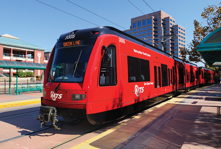
San Diego, the city to first re-introduce light rail to the West Coast (and to the country) back in 1981, now has 53 miles of light-rail track. Its most recent extension in 2005, the green line, extends from Old Town San Diego out to Santee, east of Qualcomm Stadium. The extension stretches about six miles and five stations, closing what was a gap in the system’s loop through the city.
Plans for an 11.2-mile extension from old town to UC-San Diego in La Jolla is set to be in place by 2018, said San Diego Metropolitan Transit System spokesperson Rob Schupp. Most likely the line will be an extension of the city’s blue line. Roughly $1.2 to $1.8 billion for the project comes from a local sales tax called TransNet, which will provide half the funding. The remainder of the money will come from federal funds.
Even posh La Jolla was “all for it,” said Schupp. In addition to the new lines last year, the city added $700 million worth of retrofitted light-rail vehicles (64 in all) to its Silver Line, which was completed in 2005.

Los Angeles
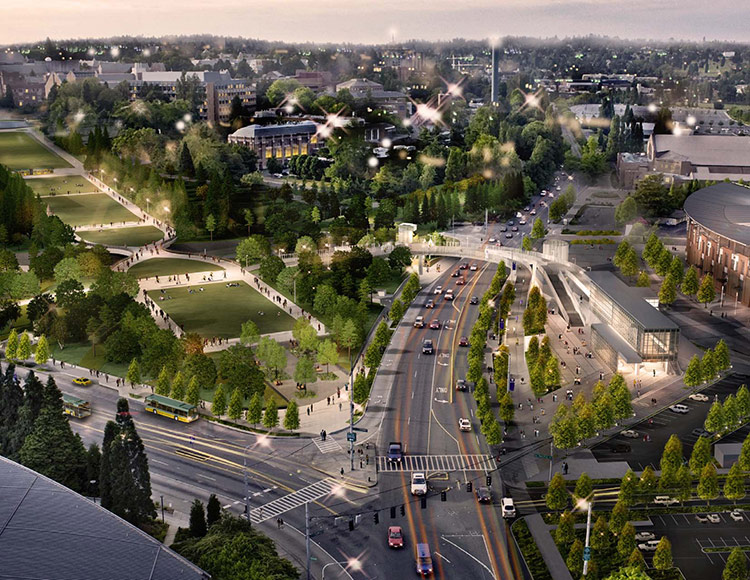
The city’s newest transit line is the Expo light-rail line, an 8.6-mile route now running from downtown LA to Culver City. By 2015 the Expo is expected to extend to Santa Monica. Designed by Gruen Associates, with support from Parsons and Miyamoto International, the line has been funded mostly by Measure R, a 2008 city sales tax increase estimated to eventually bring in from $30 to $40 billion. About 35 percent of that, up to $14 billion, will go toward rail projects.
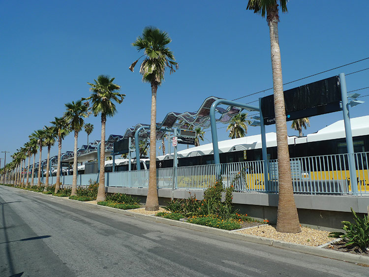 LA’s newly opened Expo line is planned to expand to Santa Monica by 2015.
Alissa Walker
|
The measure also funded an extension of Metro’s Gold Line into East LA and is helping fund the Gold Line Foothill Extension, stretching farther into the San Gabriel Valley. Other city transit projects—totaling 12 in all— include the Regional Connector, a 1.9-mile underground light-rail route linking the city’s Gold and Blue lines; extensions of Metro’s Green Line to LAX airport and farther into the South Bay; and the Purple Line subway extension down Wilshire Boulevard all the way from downtown to Westwood and, funding allowing, to Santa Monica. In fact, by the time Measure R’s funds are all spent, LA’s rail lines will have doubled, from about 60 miles to about 120, said Mieger.
Partially as a strategy to reflect LA’s diversity and partially because each line has its own construction authority, the stations along each route are widely different. The Expo’s minimal stations are highlighted by wavy metallic canopies and blue steel frames; Foothill takes on gabled roofs and a traditional vernacular; and the Gold Line into East LA has an explosion of colors and forms.

Bay Area
San Francisco opened its first light-rail line in over 50 years in 2007 with its T-Third line, which included 5.1 miles of light rail spread over 18 stations. The line has proven a huge success and brought San Francisco up to seventy miles of light-rail track. The next move for the T-Third is the T-Central subway, an underground extension of the line another 1.7 miles from Mission Bay into downtown, with stops in South of Market, Yerba Buena, Union Square, and Chinatown. The project is funded primarily via the Federal Transit Administration’s New Starts program, with about $942 million coming from that source. A combination of federal, state, and local sources will provide the remaining funds. The line is slated to open in 2019.
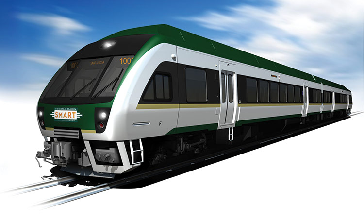 Rendering of SMART’s Diesel Multiple Unit (DMU) train.
Courtesy SMART
|
Outside of San Francisco is the Sonoma-Marin Area Rail Transit (SMART) project, largely funded by Measure Q, a 0.25 percent sales tax passed by voters in the two counties in 2008. SMART will provide rail service along 70 miles of the historic Northwestern Pacific Railroad alignment. Slowed by the economic downturn, the plan is to open a 38.5-mile initial operating segment between Santa Rosa and San Rafael by 2016, with additional segments to be opened as funding becomes available. Ultimately it will extend 70 miles. The project is the first passenger rail project in Marin and Sonoma counties since the 1950s. According to spokesperson, Matt Stevens, designs for the stations have still not been finalized, although Zimmer Gunsul Frasca (ZGF) did complete preliminary work.
Meanwhile in Silicon Valley the Santa Clara Valley Transportation Authority (VTA) is overseeing a the Capitol Expressway Light Rail Project, extending light rail by 2.3 miles and four stations in San Jose. But the big news in that area comes with heavy rail. The VTA is overseeing a $2.3 billion, 10-mile, two-station extension of the Bay Area Rapid Transit system (BART) into Silicon Valley from Fremont to North San Jose. A total of $900 million is coming from the Federal New Starts program, with $1.18 billion coming from the local half-cent Measure A sales tax. Design-build is being overseen by the joint venture team Skanska- Shimmick-Herzog. The second phase, still in project development, will reach six miles and four stations running through downtown San Jose and ending in Santa Clara. That would cost about $3.6 billion, largely because it would be underground.

Sacramento
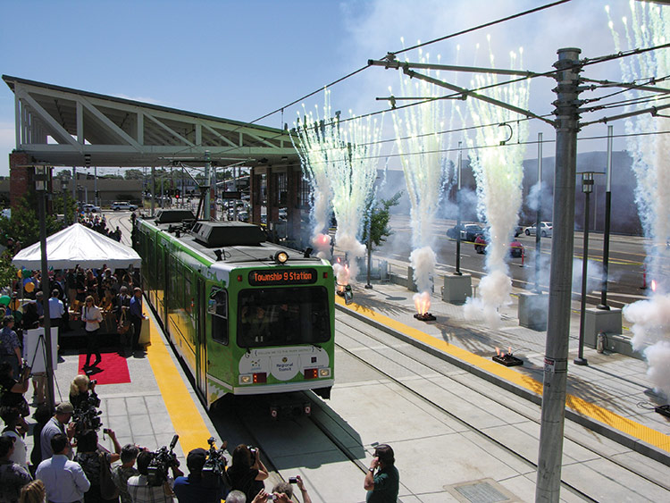
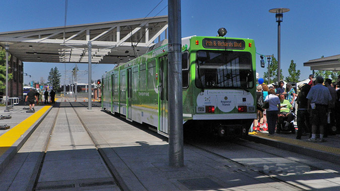
Sacramento’s contribution to the transit extravaganza is the 1.1 mile extension of its green line from downtown Sacramento north to the city’s river district. The extension just opened on June 15, to big crowds and even fireworks. The city is also planning a $270 million, four station, 4.3-mile extension of its blue line from Meadowview road to Cosumnes River College. A team of design-build architects, including Vrilakas Architects and MFDB Architects, have produced station designs unique to their locations. “We want our stations to reflect their neighborhoods,”said Sacramento Regional Transit District Architect David Solomon “It’s easier for the riders and it makes for better community building.”
Portland
With a mature and extensive system of 82 miles of track and 85 stations operating since 1986, Portland has been a model for city officials throughout the nation for how light rail can work. In 2011, over 41.2 million riders boarded Metropolitan Area Express (MAX), according to the local transit authority, TriMet.
There are currently four lines operating and a fifth—the Portland-Milwaukie MAX light rail Orange line—under construction and expected to open in September 2015. It will extend to Milwaukie in Clackamas County, 7.3 miles south of the current Yellow line that runs from the Expo Center to Portland State University.
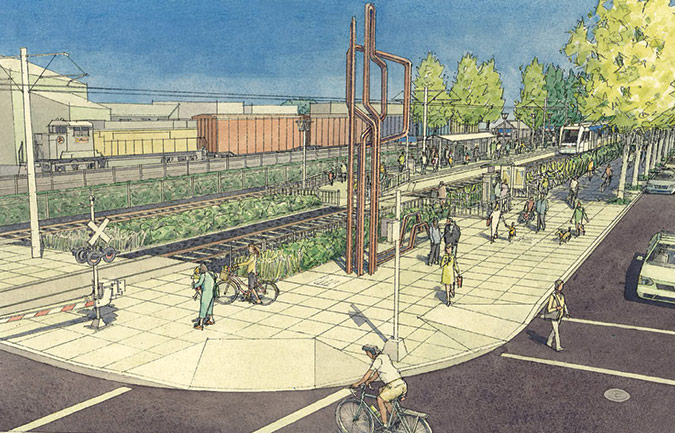
The ten stations along the Orange line will feature a mix of landscaping and public art to reflect the character of each surrounding neighborhood. The Lincoln Street/Southwest 3rd Avenue Station in the Halprin District will include a vegetated trackway dubbed an “eco-track”; at the SE Tacoma/Johnson Creek station,
a Bike and Ride station will provide secure parking for over 100 bicycles; and at the OMSI/SE Water Ave station, two artists have proposed a large “sonic dish” that will reflect sound and light as nearby commuters pass by.
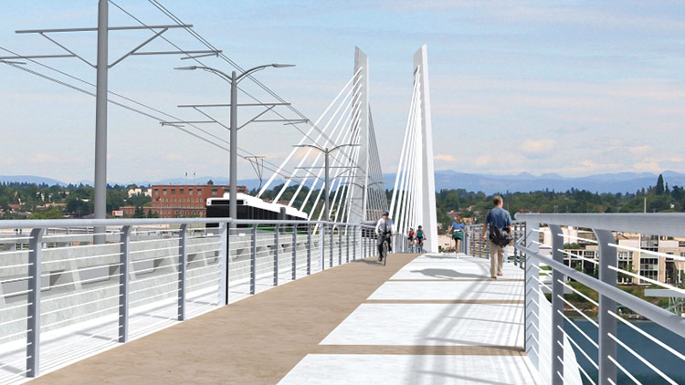
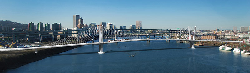
Half of the $1.5 billion project is being financed by the Federal Transit Administration, with the remainder coming from local, regional, and state sources, including $250 million in bonds financed by future Oregon Lottery revenue. This is the most expensive line Portland has ever built because it traverses urbanized land and adds a new bridge, the first to cross the Portland section of the Willamette River since the opening of the Fremont Bridge in 1973.
When open, by September 2016, the Portland-Milwaukie Light Rail Bridge in the South Waterfront District will be the first multi-modal car-free bridge in the nation. TriMet hired Donald MacDonald of MacDonald Architects, as the lead designer and chose a cable-stayed bridge design, which would help maximize horizontal and vertical clearance on the busy river and keep costs lower. Approximately 1,720 feet in length, the bridge will feature two towers and include, in addition to a light-rail track, dedicated bus lanes and two 14-foot wide paths for pedestrians and bicyclists.
Seattle
Light rail in Seattle had a shaky start ten years ago. Initially it was met with fierce opposition, then a threatened loss of funding, and eventually the resignation of the former CEO of Sound Transit, the agency that serves the Puget Sound region. But finally, after almost a decade of debating and lawsuits, the first light-rail line in the city, Sound Transit’s Central Link, opened in July 2009, a 15.5-mile route connecting downtown Seattle to Rainier Valley and SeaTac Airport.
 |
The city is now pushing forward with a huge light-rail program, with a total of 36 miles planned by 2023. This includes the University Link (U-Link) a 3.1-mile underground section running from downtown Seattle north to the University of Washington, scheduled to open in September 2016. There are three more planned sections: a 1.3-mile section south toward Tacoma to open in 2016; a north leg to Northgate and eventually Lynnwood that will open in 2021; and a 14.5-mile extension east over the I-90 bridge through Mercer Island to Bellevue that will open in 2023.
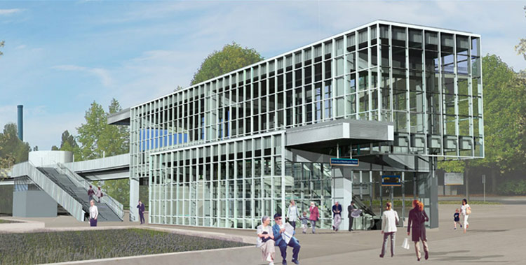
Construction of the U-Link is now underway. At the University of Washington station, designed by LMN Architects, a pedestrian bridge will traverse Montlake Boulevard, linking the upper campus, the University of Washington Medical Center, and the 27-mile Burke-Gilman Trail, affording views on a clear day of Mount Rainier.
Total funding for the U-Link project is $1.9 billion, with $750 million derived from a blend of grants from the Federal Transit Administration, including a TIGER I competitive grant, as well as local support. In 2008, voters approved the Sound Transit 2 measure, increasing sales tax and motor vehicle excise tax.
“It’s so nice to discover that after all these years we’re not done yet, and we can still change our cities,” said SPUR’s Metcalf.