


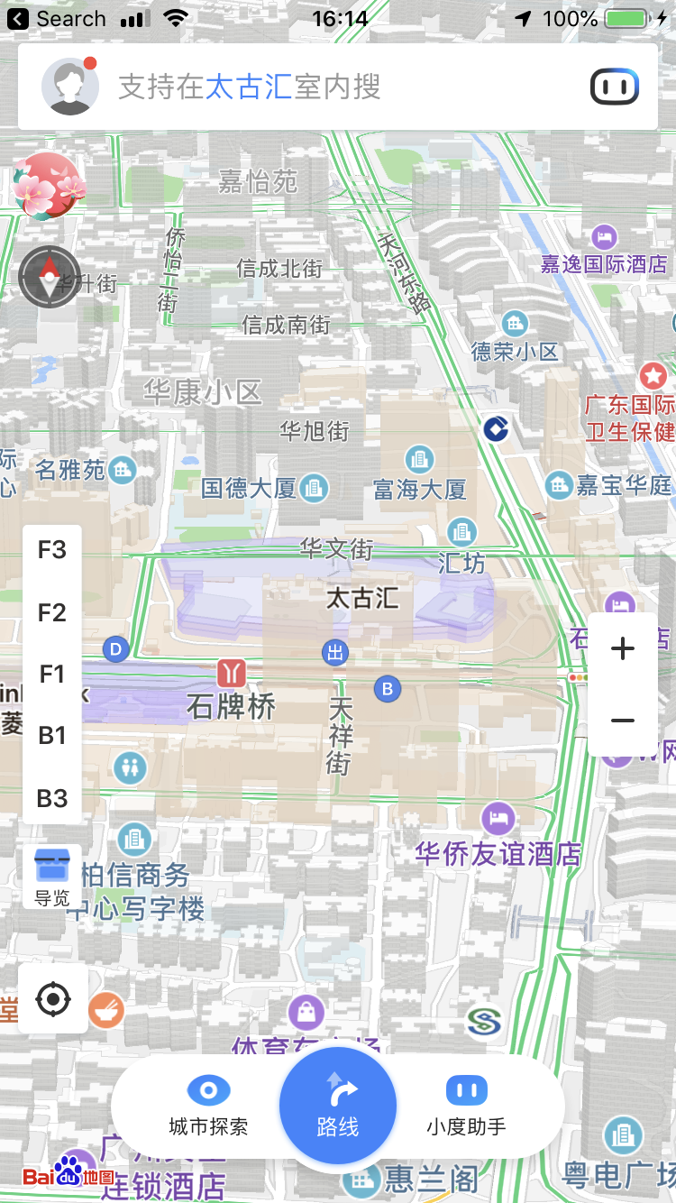
Level 3, number 203. Turn right 10 feet. Go straight for 15 feet. The best way to experience data’s strong grip on everyday life in China is to open up Baidu Maps, a mapping app by China’s biggest search engine company, and walk around a shopping mall for one afternoon. Inside the building, a network of Bluetooth beacons, Wi-Fi modems, and satellites from a global navigation satellite system whir and ping through the air and the ionosphere to determine your precise location. The map on the Baidu app tilts to reveal an elaborately modeled 3-D cityscape.
The resolution of Baidu Maps is stunning: Entire cities are modeled in 3-D. Within public buildings, the floorplan of each building level is precisely mapped. As I stand inside the Taikoo Hui Mall in the city of Guangzhou, China, I search for a store within the mall. Baidu Maps reveals which level the store is on and how many meters I need to walk. Strolling through the mall with the app tracking my location with a blue dot on the screen, life starts to feel like a virtual reality experience. The difference between the map’s 3-D model and the reality beneath my feet is smaller than ever. The 3-D model makes an uncanny loop: Virtual models were used by architects and designers to design these spaces, which now unfold on a messy plane between real space and screen space.
China now has its own tech giants—Alibaba, JD.com, Tencent Holdings, and Baidu—homegrown behind the Great Firewall of China. Like their American counterparts, these companies have managed to surveil their users and extract valuable data to create new products and features. Baidu began as a search engine, but has now branched out into autonomous driving, and therefore, maps. The intricacy of its 3-D visualizations is the result of over 600 million users consulting the app for navigation every day or using apps that rely on Baidu Maps in the background, such as weather apps that rely on its geolocation features.
The tech company, like its counterparts such as Google, take advantage of multiple features available in smartphones. Smartphones possess the ability to determine users’ positions by communicating with an array of satellites such as GPS (Global Positioning Service); GLONASS, Russia’s version of GPS; or BeiDou, China’s satellite navigation system. Such satellite systems are public infrastructures created by American, Russian, and Chinese governments, respectively, that enable our phones to determine users’ precise longitude and latitude coordinates. The majority of apps and services on smartphones rely on location services, from food delivery to restaurant reviews. However, satellite navigation systems are still imprecise—they are often a few meters off, with anything from the weather to tall buildings affecting accuracy.
However, smartphones contain more than satellite signal receiver chips. A slew of other sensors, such as accelerometers, light sensors, and magnets are embedded in the average smartphone. In 2015, Baidu invested $10 million in IndoorAtlas, a Silicon Valley startup that specializes in indoor mapping. The company’s technology is at the forefront of magnetic positioning, which allows indoor maps at 1-meter accuracy to be created simply by using an average smartphone. This technology relies on the Earth’s geomagnetic field and the magnets in smartphones. By factoring in the unique magnetic “fingerprint” of each building based on the composition of its materials, such as steel, a building’s floor plan can be mapped out without any data provided by the architect. However, this strategy requires user data at scale; multiple user paths need to be recorded and averaged out to account for any anomalies. Gathering large amounts of data from users becomes an imperative.
Floorplans aside, magnetic positioning is not the only dimension of user location data collection that allows data to become a spatial model. As people drive, bike, and walk, each user generates a spatial “trace” that also has velocity data attached to it. Through such data, information about the type of path can be derived: Is it a street, a sidewalk, or a highway? This information becomes increasingly useful in improving the accuracy of Baidu Maps itself, as well as Baidu’s autonomous vehicle projects.
The detailed 3-D city models on Baidu Maps offer data that urban designers dream of, but such models only serve Baidu’s interests. Satellite navigation system accuracy deteriorates in urban canyons, due to skyscrapers and building density, obscuring satellites from the receiver chip. These inaccuracies are problematic for autonomous vehicles, given the “safety critical” nature of self-driving cars. Baidu’s 3-D maps are not just an aesthetic “wow factor” but also a feature that addresses positioning inaccuracies. By using 3-D models to factor in the sizes and shapes of building envelopes, inaccuracies in longitude and latitude coordinates can be corrected.
Much of this research has been a race between U.S. and Chinese companies in the quest to build self-driving cars. While some 3-D models come from city planning data, in China’s ever-changing urban landscape, satellite data has proved far more helpful in generating 3-D building models. Similar to Google’s 3-D-generated buildings, a combination of shadow analysis, satellite imagery, and street view have proved essential for automatically creating 3-D building models rather than the manual task of user-generated, uploaded buildings or relying on city surveyors for the most recent and accurate building dimensions.
None of this data is available to the people who design cities or buildings. Both Baidu and Google have End User License Agreements (EULAs) that restrict where their data can be used, and emphasize that such data has to be used within Baidu or Google apps. Some data is made available for computer scientists and self-driving car researchers, such as Baidu’s Research Open-Access Dataset (BROAD) training data sets. Most designers have to rely on free, open-source data such as Open Street Maps, a Wikipedia-like alternative to Baidu and Google Maps. By walling off valuable data that could help urban planning, tech companies are gaining a foothold and control over the reality of material life: they have more valuable insights into transport networks and the movements of people than urban designers do. It’s no surprise then, that both Baidu and Google are making forays into piloting smart cities like Toronto’s Quayside or Shanghai’s Baoshan District, and gaining even greater control over urban space. No doubt, urban planning and architecture are becoming increasingly automated and privately controlled in the realm of computer scientists rather than designers.

In Shoshana Zuboff’s 2019 book, The Age of Surveillance Capitalism, she examines how tech companies throughout the world are employing surveillance and data extraction methods to turn users into free laborers. Our “behavioral surplus,” as she terms it, becomes transformed into products that are highly lucrative for these companies, and feature proprietary, walled-off data that ordinary users cannot access, even though their labor has helped create these products. These products are also marketed as “predictive,” which feeds the desires of companies that hope to anticipate users’ behavior—companies that see users only as targets of advertising.
Over the past several years, American rhetoric surrounding the Chinese “surveillance state” has reached fever pitch. But while China is perceived to be a single-party communist country with state-owned enterprises that do its bidding, the truth is, since the 1990s, much of the country’s emphasis has been on private growth. Baidu is a private company, not a state-owned enterprise. Companies like Baidu have majority investment from global companies, including many U.S.-based funds like T. Rowe Price, Vanguard, and BlackRock. As China’s economy slows down, the government is increasingly pressured to play by the rules of the global capitalist book and offer greater freedom to private companies alongside less interference from the government. However, private companies often contract with the government to create surveillance measures used across the country.
The rhetoric about the dangers of Chinese state surveillance obfuscates what is also happening in American homes—literally. As Google unveils home assistants that interface with other “smart” appliances, and Google Maps installed on mobile phones tracks user locations, surveillance becomes ubiquitous. Based on your location data, appliances can turn on as you enter your home, and advertisements for milk from your smart fridge can pop up as you walk by the grocery stores. Third-party data provider companies also tap into geolocation data, and combined with the use of smart objects like smart TVs, toasters, and fridges, it’s easy to see why the future might be filled with such scenarios. Indeed, if you own certain smart appliances, Google probably knows what the inside of your home is like. In 2018, iRobot, the maker of the Roomba vacuum, announced that it was partnering with Google to improve the indoor mapping of homes, and now setting up a Roomba with Google Home has never been easier. Big tech companies in the U.S. would like us to believe that surveillance is worse elsewhere, when really, surveillance capitalism is a global condition.
Over the past 30 years, cities around the world have been the locus of enormous economic growth and corresponding increases in inequality. Metropolitan areas with tech-driven economies, such as the Shenzhen-Guangzhou-Hong Kong corridor and the Greater Bay Area, are home to some of the largest tech companies in the world. They are also home to some of the most advanced forms of technological urbanism: While Baidu may not have every single business mapped in rural China, it certainly has the listing of every shop in every mall of Guangzhou.
The overlap between cities as beacons of capital and as spaces where surveillance is ubiquitous is no coincidence. As Google’s parent company, Alphabet, makes moves to build cities and as Baidu aggressively pursues autonomous driving, data about a place, the people who live there, and their daily movements is increasingly crucial to the project of optimizing the city and creating new products, which in turn generates more wealth and more inequality. Places like San Francisco and Shenzhen are well-mapped by large tech companies but harbor some of the worst income gaps in the world.
The “smart city” urbanism enabled by surveillance and ubiquitous data collection is no different from other forms of development that erode affordable housing and public space. Reclaiming our cities in this digital age is not just about reclaiming physical space. We must also reclaim our data.


